The question of how to tell longitude accurately was contested for a very long time. People had figured out
how to tell latitude by use of a device that would give them the angle between a star and a horizon (usually the sun or the north star). In other words they could tell where they were when moving North or South.
They just didn't know how to tell precisely where they were when going East to West. They could divide their sphere into longitudes but they couldn't tell precisely where their ship was during its travels:
 |
| Earth Divided into Longitudes: A Polar Projection or Looking On Earth From Above |
We were interested in finding the distance we had traveled and we did it by dividing the earth into equal parts (longitudes).
The first workable answer used by the mariners came with the invention of the clock (or the
chronometer) by
John Harrison.
 |
| The Harrison Chronometer or clock or fancy term "chronometer" (chrono:time; meter:measure-er).Perhaps use of easier, briefer words could make knowledge more accessible? |
This is perhaps how they did it:
Once again we used the angle between the sun and the horizon. For example you expect the sun to be straight over head when its noon and make an angle of 90 degrees with the horizon. At 11 o Clock you expect it to be at an angle of 60 degrees.
 |
| The Sun And Its Journey through the day |
The sun and earth actually looks so when the earth is rotating on its axis :
 |
| Sun lights up the earth as it rotates |
As you can see below the sun is automatically demarcating the longitude for us :
 |
| Sun is in effect marking the longitude for us |
How do we use this information to tell what longitude we are in?
First we pick a reference point : in the case of human kind we picked Greenwich, London.
 |
| Reference Point London If you look at Earth From Above |
This is because England developed this method and her sailors and navy has been renowned for a long time; btw. that is also the origin of Greenwich Mean Time or GMT as the point of reference.
We set our clock (or chronometer) to the time in London.
Then we go with our clock (or chronometer) set to London time (Greenwich Mean Time or GMT) on board a ship. We then travel far away from London and head into the Atlantic ocean.
 |
| We are interested in finding our Longitude : Or Angle Between the Sun at Noon (In London) and Our Position |
When our clock (set to the time in London) says 12 o' clock (noon) we expect the sun to be directly over London. In other words we expect the sun to be directly aligned with London:
 |
| This is What Earth Looks Like When the Sun is Directly Above London |
We know that since our on board clock(set to London time) which we carried with our ship , says it is noon it means that in London the sun would be directly overhead or as we say at 0 degrees Longitude (since we decided it was a reference point). Knowing that if London is at 0 degree longitude? (ground zero) where are we located or rather what is our longitude compared to London's?
To find that out we go on the deck of our ship and with our sextant (or
any of the measuring devices) we measure the angle of the sun with the horizon at our location:
Suppose our sextant tells us that the angle of the sun with the horizon is 70 degrees. This where we would be on earth :
 |
| This is where we will be in the Atlantic Ocean with the Sun at 70 degrees overhead and our clock saying its noon in London |
This means that we are not located too far away (from London) and it does look like the sun is almost over our heads as well and the earth rotating in due time will have the sun above our heads very soon. Remember this is what the sun looks like when it is at 70 degrees:
 |
| Sun At Our Location aboard a ship in the Atlantic |
We are interested in finding out the longitude though which is the following angle marked with a question mark:
|
| The longitude would be the angle between us and London (our reference) marked in red question mark. |
Our longitude can be told by looking at the angle between the sun and our our longitude
(our position on the polar projection of the map).
If you look at the above and take out the triangles formed between the sun, the ship and the location of London:
 |
| Focusing on Lines In the Map Above we Get The Above Similar Triangles. |
If A is the location of London (as in the map above) and B is the location of the ship. D is the pole and the C is the location of the Sun. By Side Angle Side(SAS) (Side AB is common, Angle( DAB) and Angle(CAB) are same and sides AD and AC are proportional) we see that Triangle ADB and Triangle ACB are similar triangles. By similar triangles we know that Angle (ADB) and Angle (ACB) are equal. Angle (ABC) is the angle of the sun with the horizon which we found to be 70 degrees (using a sextant or any other measurement tool). If we know Angle (ABC) (70 deg) we know that Angle (ACB) is 90-70=
20 degrees.
So Angle (ADB) or our angle with London's Longitude (Longitude 0) will be 20.
Thus we can tell our position on the longitude with great precision using the clock (set to the time in London and using a sextant or any other device that measures the angle of the sun with the horizon). But an angle is not very useful. We really want to know how far from London we really are. We were only trying to find this angle so we could tell the longitude (or the partition that earth was divided into) . Once we know this angle we or partition we could tell how far we are from London.
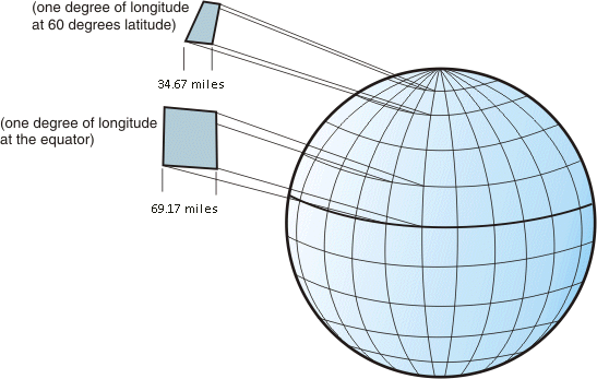
Once you have found the angle you may wish to know how far you are from London in miles. If you want to know the distance then knowing the angle is not enough. You
must know the latitude as well because the distance varies from latitude to latitude:
 |
| Distance between Longitudes varies as Latitude Varies |
In our case if we were at the same latitude as London (50 degrees) then we would be approximately (44.55x2=89 miles) 89 miles west of London, perhaps. Again we were able to tell all of this because we had a watch that was set to London time (GMT) which allowed us to discern our position relative to the city.
The struggle to come up with accurate measurements of longitude took centuries and this method came about in the 1700s after many other schemes failed or were found unworkable. The greatest minds human kind had ever produced thought about this problem and both
Galileo and
Huygen proposed their solution (even Newton is said to have tackled this problem though his idea was not used). Galileo proposed that we use the moons of Jupiter but it is said that his relations with the Church caused that idea to go unnoticed. Today we use satellites which can accurately pin point our position in orbit. They have been in use for over half a century (first in military and only recently in civilian use). Only the most learned of civilizations have their own systems (US, EU, Japan, Russia, China and India!). All their systems are therefore likely to be mostly redundant, however it would serve all of them well if they cooperated and made their systems into extensions (rather than as mere alternatives or backups or competing systems).
 |
| Some 300 years later we use GPS! |
p.s. if the reader would be kind enough to please correct any errors if possible that would be great. One is using "we" when speaking of discoveries and methods used by a prettier and smarter and gentler people; one apologizes for this presumption and hopes all are become gentle and pretty and smart. It is also quite lamentable that one comes from a society where people are merely catching up with the developed world and are unable to make original , positive and significant contributions of their own. We hope all are worthy and able to make all places not merely better but perfect for love and life.